1575 posts
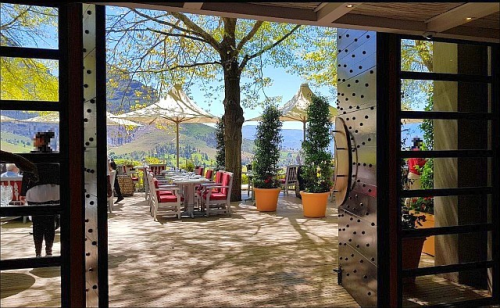
Delaire Graff Takes Advantage Of Its Ideal Setting On The Ridge Of The Helshoogte Mountain Pass In Stellenbosch,
Delaire Graff takes advantage of its ideal setting on the ridge of the Helshoogte Mountain Pass in Stellenbosch, by producing elegant, full bodied reds and crisp, clean whites. Matching the elegance of the estate's wines is a difficult task but its restaurants - Delaire Graff and Indochine -- more than meet the challenge by setting ego aside and allowing locally grown produce to play the hero of each plate. By booking a day tour to the Cape Winelands you'll get the chance to explore Delaire Graff and other estates like it. For those after a more holistic experience, you'll need to stay in one of the estate's luxury lodges.
Das Delaire Graff Lodges & Spa ist ein erstklassiges Weingut mit Restaurant, Hotel und Spa am Helshoogte Pass zwischen Stellenbosch und Franschhoek. Bei einer Weinprobe auf der Terrasse werden Sie in den Genuss des schönen Ausblicks auf die Berglandschaft, das Weinbaugebiet und den gepflegten Garten kommen. Delaire Graff nutzt seine ideale Lage auf dem Kamm des Helshoogte Mountain Pass in Stellenbosch, indem er elegante, vollmundige Rotweine und frische, saubere Weißweine produziert.


-
 logi1974 liked this · 5 years ago
 -
 cherishloveadore liked this · 5 years ago
More Posts from Logi1974
In der scheinbar unendlichen Weite der Kunene Region sind sie Zuhause, die Wüstenelefanten Namibias. Wüstenelefanten sind schlanker als ihre Artgenossen, haben längere Beine und größere Füße, damit sie weiter und ohne einzusinken durch die sandige Wüste wandern können. Etwa 70 Kilometer legt ein Wüstenelefant täglich auf der Suche nach Futter zurück und damit sieben Mal so viel wie ein Elefant in einem wasserreichen Gebiet.
They are at home in the seemingly endless vastness of the Kunene region, the desert elephants of Namibia. Desert elephants are slimmer than their relatives, have longer legs and larger feet so that they can walk further and without sinking in the sandy desert. A desert elephant travels about 70 kilometers a day looking for food, seven times as much as an elephant in a water-rich area.


The origins of our Namibian stones reach far back in time. Specific regimes of conditions, temperature, pressure, minerals and elements collaborated along the long Earth journey to produce the magnificent array of colourful gemstones we are familiar with today - like amethyst, clear and smoky quartz, topaz, tourmaline, fluorite and aquamarine. Adding to their authenticity, they are mined by local miners around the Brandberg, Erongo and Spitzkoppe area, Namibian men and women who work long hours under harsh conditions in the sweltering Namibian sun.
Die Ursprünge unserer namibischen Steine reichen weit in die Vergangenheit zurück. Während der langen Erdreise haben bestimmte Bedingungen, Temperatur, Druck, Mineralien und Elemente zusammengearbeitet, um die großartige Auswahl an bunten Edelsteinen herzustellen, mit denen wir heute vertraut sind - wie Amethyst, klarer und rauchiger Quarz, Topas, Turmalin, Fluorit und Aquamarin. Zusätzlich zu ihrer Authentizität werden sie von lokalen Bergleuten in der Umgebung von Brandberg, Erongo und Spitzkoppe abgebaut, namibischen Männern und Frauen, die lange Stunden unter rauen Bedingungen in der drückenden namibischen Sonne arbeiten.


The Okavango Delta is one of the largest and most important inland wetlands of the world, covering 16,000 km², with 2500 species of plants, 65 fish species, 20 large herbivores and over 450 species of birds.
Das Okavango Delta ist eines der größten und wichtigsten, sich im Binnenland befindliche Feuchtgebiet, und umfasst 16 000 km2 mit 2500 Pflanzenarten, 65 Fischarten, 20 großen Pflanzenfressern und 450 Vogelarten.


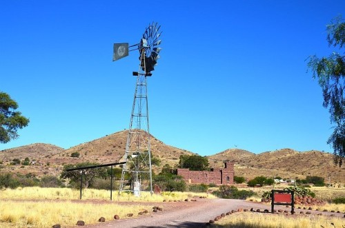
In a semi-arid country like Namibia, where deserts fringe both the eastern and western borders, water is a precious resource. At the onset of summer towards the end of the year, Namibians watch the skies expectantly waiting for the clouds to gather and the first raindrops to hit the parched earth. For such a country, it is no wonder that the symbol of a windmill is one that has been ingrained in generations of Namibians, representing hope and life as it catches the wind and turns, pumping up water from underground reservoirs.
In einem halbtrockenen Land wie Namibia, in dem Wüsten sowohl an der Ost- als auch an der Westgrenze liegen, ist Wasser eine wertvolle Ressource. Zu Beginn des Sommers, gegen Ende des Jahres, beobachten Namibier den Himmel und warten erwartungsvoll darauf, dass sich die Wolken sammeln und die ersten Regentropfen auf die ausgedörrte Erde treffen. Für ein solches Land ist es kein Wunder, dass das Symbol einer Windmühle in Generationen von Namibiern verwurzelt ist und Hoffnung und Leben repräsentiert, wenn es den Wind fängt und sich dreht und Wasser aus unterirdischen Stauseen aufpumpt.


Das Sossusvlei ist eine Salz-Ton-Pfanne, welche von Dünen umschlossen ist. In der Sprache der Nama bedeutet Sossus soviel wie blinder Fluss, da der Tsauchab-Fluss, wenn er mal Wasser führt, auf dem Weg zur Pfanne versickert, ohne die Atlantikküste, welche nur 50 km entfernt ist, oberirdisch zu erreichen. Durch Versandung und Abschnitt des Flusses entstanden über die gesamten 50km bis zum Atlantik verschiedene Vleis, wovon das Sossusvlei das berühmteste ist. Der Wind tat ein Übriges und bildete die bis zu 300 m hohen Dünen, die höchsten der Welt, welche die Pfanne umgeben.
The Sossusvlei is a salt-clay pan surrounded by dunes. In the Nama language Sossus means something like “blind river” and refers to the Tsauchab River, which when in flood seeps away in the desert without reaching the only 50 km far Atlantic above ground. Due to sanding up and cutting off of the river the whole 50 km to the Atlantic consists of different vleis, of which the Sossusvlei is the best known. To compound the situation the wind formed the famous up to 300 metre high dunes, which surround the vleis.


