1575 posts
Bis Noch Vor Etwa 100 Jahren Waren Elefanten Auf Dem Gesamten Afrikanischen Kontinent Verbreitet. Die
Bis noch vor etwa 100 Jahren waren Elefanten auf dem gesamten afrikanischen Kontinent verbreitet. Die Wilderei für den Elfenbeinhandel hat sie in weiten Gebieten ausgerottet: Afrikanische Elefanten leben heute nur noch südlich der Sahara. Der größte Bestand befindet sich im südlichen Afrika, insbesondere in Botswana.
-------------------------
Until about 100 years ago, elephants were common across the African continent. Poaching for the ivory trade has wiped them out in large areas: African elephants now only live south of the Sahara. The largest population is in southern Africa, especially in Botswana.


-
 leonardmatter liked this · 3 years ago
 -
 phoenixkluke liked this · 3 years ago
 -
 fateliveswithin liked this · 4 years ago
 -
 sablelab liked this · 4 years ago
 -
 logi1974 liked this · 4 years ago
More Posts from Logi1974
The Cape of Good Hope is a rocky headland on the Atlantic coast of the Cape Peninsula in South Africa. A common misconception is that the Cape of Good Hope is the southern tip of Africa. This misconception was based on the misbelief that the Cape was the dividing point between the Atlantic and Indian Oceans. Contemporary geographic knowledge instead states the southernmost point of Africa is Cape Agulhas about 150 kilometres to the east-southeast. The currents of the two oceans meet at the point where the warm-water Agulhas current meets the cold-water Benguela current and turns back on itself. That oceanic meeting point fluctuates between Cape Agulhas and Cape Point (about 1.2 kilometres) east of the Cape of Good Hope. Cape Point, a World Heritage Site, and protected Nature Reserve is an area of vast natural beauty, world renown for it natural vegetation and rich bio-diversity. Part of the Table Mountain National Park that extends from Signal Hill in the north all the way to Cape Point in the south. This said, the Cape of Good Hope is one of two world-renowned landmarks within the Table Mountain National Park, the other is Table Mountain. These two familiar attractions are what draws thousands of visitors to Cape Town. Most visitors to Cape Town regard a trip to the Cape of Good Hope and Cape Point (the tip of the Cape peninsula) as obligatory. This part of the park is home to an array of fynbos, over 250 species of birds, buck, baboons and Cape mountain zebra. There are numerous picnic spots, paths on which one can set off on foot or mountain bike, and tidal pools on almost isolated beaches.
-----------------------
Das Kap der Guten Hoffnung ist eine felsige Landzunge an der Atlantikküste der Kaphalbinsel in Südafrika. Ein häufiges Missverständnis ist, dass das Kap der Guten Hoffnung die Südspitze Afrikas ist. Dieses Missverständnis beruhte auf dem Irrglauben, dass das Kap der Trennungspunkt zwischen dem Atlantik und dem Indischen Ozean sei. Zeitgenössisches geografisches Wissen besagt stattdessen, dass der südlichste Punkt Afrikas das Kap Agulhas ist, etwa 150 Kilometer östlich-südöstlich. Die Strömungen der beiden Ozeane treffen sich an dem Punkt, an dem der Warmwasser-Agulhas-Strom auf den Kaltwasser-Benguela-Strom trifft. Dieser ozeanische Treffpunkt schwankt zwischen Cape Agulhas und Cape Point (ca. 1,2 km) östlich des Kaps der Guten Hoffnung. Cape Point, ein Weltkulturerbe und geschütztes Naturschutzgebiet, ist ein Gebiet von großer natürlicher Schönheit, weltbekannt für seine natürliche Vegetation und seine reiche biologische Vielfalt. Das Kap der Guten Hoffnung ist Teil des Tafelberg-Nationalparks, der sich vom Signal Hill im Norden bis nach Cape Point im Süden erstreckt. Das Kap der Guten Hoffnung ist eines von zwei weltbekannten Wahrzeichen im Nationalpark Tafelberg, das andere ist der Tafelberg. Diese beiden bekannten Attraktionen ziehen Tausende von Besuchern nach Kapstadt. Die meisten Besucher Kapstadts betrachten eine Reise zum Kap der Guten Hoffnung und nach Cape Point (der Spitze der Kaphalbinsel) als obligatorisch. In diesem Teil des Parks wächst eine Reihe von Fynbos, über 250 Vogelarten, Antilopen, Paviane und Kapbergzebras. Es gibt zahlreiche Picknickplätze und Wege, auf denen man zu Fuß oder mit dem Mountainbike losfahren kann, sowie Gezeitenbecken an fast einsamen Stränden.


Omaruru was established in 1863 by Wilhelm Zeraua, the first chief of the White Flag clan of the OvaHerero people. In 1871, Anders Ohlsson and Axel Eriksson established a brewery at Omaruru. Eriksson had also established a trading post, which flourished and by 1878 he employed about forty whites. Eriksson's business was based upon long-distance trading between southern Angola and Cape Colony, which necessitated the establishment of regional trade routes.
The town grew around a mission built in 1872 by Gottlieb Viehe, now a museum, and was attacked in 1904 during the Herero Wars. Franke Tower was later erected to commemorate the relief by Hauptmann Victor Franke's troops of the local garrison that was beleaguered by Herero tribesmen who had risen against the German colonial presence.
------------------------
Omaruru wurde 1863 von Wilhelm Zeraua, dem ersten Chef des Clans der OvaHerero aus dem “weißen Haus”, gegründet. 1871 eröffneten Anders Ohlsson und Axel Eriksson eine Brauerei in Omaruru. Eriksson hatte auch einen Handelsposten eingerichtet, der florierte, und bis 1878 beschäftigte er etwa vierzig Weiße. Erikssons Geschäft basierte auf dem Fernhandel zwischen Südangola und der Kapkolonie, was die Einrichtung regionaler Handelsrouten erforderlich machte.
Die Stadt entstand um eine Mission, die 1872 von Gottlieb Viehe, heute ein Museum, erbaut wurde und 1904 während der Herero-Kriege angegriffen wurde. Der Franke-Turm wurde später errichtet, um an die Befreiung der örtlichen Garnison durch Hauptmann Victor Frankes Truppen zu erinnern, die von Herero-Stammesangehörigen belagert wurde, die sich gegen die deutsche Kolonialpräsenz erhoben hatten.


Katutura is a township of Windhoek in Namibia. Katutura is Otjiherero for “The place where we do not want to live”. Katutura was created in 1961 as an aftermath of the forced removal of Windhoek’s black population from the Old Location, which later was developed into the suburb of Hochland Park. The Windhoek municipality and the South African colonial administration decided to forcefully move the residents of the Old Location 8 kilometres to the north of the city. Sam Nujoma Stadium, built in 2005, is located within Katutura. Katutura Community Radio, a community-based radio station, also operates from the township as well Katutura State Hospital, one of two State Hospitals in the Windhoek area.
——————————————
Katutura ist ein Township in Windhoek in Namibia. Katutura in der Sprache Otjiherero bedeutet: “Der Ort, an dem wir nicht leben wollen”. Katutura wurde 1961 als Folge der erzwungenen Umsiedelung der schwarzen Bevölkerung von Windhoek aus dem Bereich gegründet, der später zum Vorort des Hochlandparks ausgebaut wurde. Die Gemeinde Windhoek und die südafrikanische Kolonialverwaltung beschlossen, die Bewohner 8 Kilometer nördlich der Stadt gewaltsam anzusiedeln. Das 2005 erbaute Sam Nujoma Stadium befindet sich in Katutura. Das Katutura Community Radio, ein in der Gemeinde ansässiger Radiosender, ist ebenfalls in der Gemeinde tätig, ebenso wie das Katutura State Hospital, eines von zwei staatlichen Krankenhäusern in der Region Windhoek.


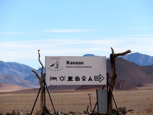
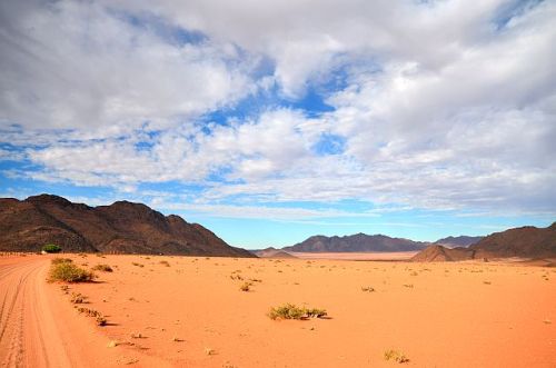
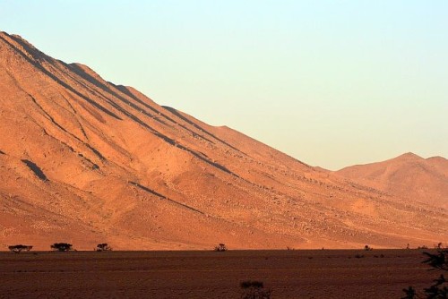
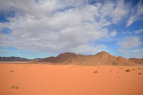
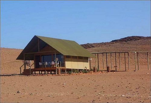
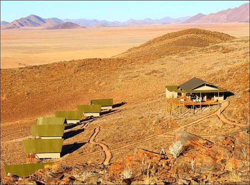
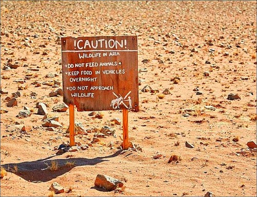
35000 hectares of beautifully preserved landscape in the Namib Desert is a photographer’s paradise. With endless red dunes, crystal clear night skies, and mouth-watering, homemade cuisine - Kanaan is the ultimate eco-tourism destination. Bordering the Tiras Mountain range, Kanaan is where nature, luxury and conservation meet. Since acquiring the land in 2014, Naankuse has removed all man-made fences to create a wildlife reserve that provides refuge to a number of endemic animal species.
---------------------------
35000 Hektar wunderschön erhaltener Landschaft in der Namib-Wüste sind ein Paradies für Fotografen. Mit endlosen roten Dünen, kristallklarem Nachthimmel und hausgemachter Küche - Kanaan ist das ultimative Reiseziel für Ökotourismus. Kanaan grenzt an das Tiras-Gebirge und ist der Ort, an dem Natur, Luxus und Naturschutz aufeinandertreffen. Seit dem Erwerb des Landes im Jahr 2014 hat Naankuse alle künstlichen Zäune entfernt, um ein Wildreservat zu schaffen, das einer Reihe endemischer Tierarten Zuflucht bietet.


42 km south of Walvis Bay Sandwich Harbour is situated. The name Sandwich Harbour refers to the former harbour as well as the lagoon. Sandwich harbour is only accessible by 4x4. The harbour was founded in 1486 already by Portuguese sailors. It is not known what importance the harbour had at that time. There are sources that claim that there was a moderately sized commercial port based around whaling and small scale fishing during the 19th century. In 1884 the hard to reach harbour gained more importance as a supply harbour for the colony German South-West-Africa. This only lasted a few years as it was replaced by the harbour in Swakopmund. Today Sandwich Harbour is of touristic interest and does not refer to the forgotten harbour, but solely to the lagoon.
-----------------
42 km südlich von Walvis Bay liegt Sandwich Harbour, welches früher auch Sandwich-Hafen oder Sandwichbucht genannt wurde. Die Bezeichnung Sandwich Harbour beinhaltet einmal den ehemaligen Hafen und zum anderen die Lagune. Sandwich Harbour kann nur im Allradauto besucht werden. Der Hafen wurde hier schon 1486 von portugiesischen Seefahrern gegründet. Inwieweit der Hafen schon damals Bedeutung hatte, ist nicht bekannt. Es gibt aber Überlieferungen, wonach sich im 19. Jahrhundert hier ein Fischereihafen befand, der zugleich Anlaufpunkt für Abenteurer und Walfänger war. Der schwierig zu erreichende Hafen erlangte ab 1884 Bedeutung als Versorgungshafen für die Kolonie Deutsch-Südwestafrika, verlor allerdings nach wenigen Jahren seine Grundlage als Hafen zugunsten des Hafens Swakopmund. Wenn heute Sandwich Harbour im touristischen Interesse steht, so ist nicht der längst vergessene Hafen, sondern die gleichnamige Lagune gemeint.


