- Tumblr Posts


Гора Кука (Аораки) - наивысшая точка Новой Зеландии, высота которой составляет 3754 метра над уровнем моря, расположена в западной части Южного острова, в новозеландских Южных Альпах. Гора состоит из трёх пиков - самый низкий из них имеет высоту 3593 метра над уровнем моря, средний - 3717 метров и самый высокий - 3754 метра. Гора Кука сложена из кристаллических пород, имеет форму седла с крутыми склонами, а её вершина покрыта вечными снегами и ледниками. Вдоль восточного фланга горы спускается знаменитый ледник Тасмана - крупнейший ледник в Новой Зеландии, протяжённостью 29 километров и площадью 156,5 квадратных километров. Нижняя часть горных склонов покрыта уникальными дождевыми лесами умеренного климата и живописными альпийскими лугами, в которых произрастают эндемичные виды растений и редкие виды животных, встречающиеся только в Новой Зеландии.
Для маори, коренного населения Новой Зеландии, Аораки является священной горой, на языке племени Нгай Таху название горы означает "большое белое облако". Английское название Mount Cook (Гора Кука) дал горе в 1851 году капитан Джон Лорт Стокс в честь знаменитого мореплавателя Джеймса Кука. С момента открытия горы европейцами, её вершина постоянно манит альпинистов со всего мира. Несмотря на то, что Аораки - далеко не самая высокая гора на планете, она является технически очень сложной для восхождения. Огромную опасность для альпинистов представляют резкая смена погоды, сильные снегопады, высокий уровень обледенения скал, большие трещины ледников и высокая вероятность внезапного схода лавин. Только с начала XX века при восхождении на гору Кука погибло около 80 альпинистов, что делает её самым смертоносным пиком в Новой Зеландии. Не даром в легендарной эпопее Джона Толкина "Хоббит, или Туда и обратно", "Властелин колец" и "Сильмариллион" гора Кука стала прототипом пика Карадрас - одного из высочайших пиков Мглистых гор в Средиземье. Именно под Карадрасом был построен великий город гномов Казад-Дум
В 1953 году на территории вокруг горы Кука был создан Национальный парк Маунт-Кук, в который входят 19 горных пиков высотой более 3000 метров над уровнем моря и 8 (из 12) крупнейших ледников в Новой Зеландии. Парк является частью района Те-Вахипунаму, внесенного в список Всемирного наследия ЮНЕСКО за выдающуюся природную ценность. Помимо занятий альпинизмом (восхождение на вершину разрешено только опытным альпинистам в сопровождении горных проводников), посетители парка могут заняться скалолазанием, трекингом, горным велосипедом, охотой и насладиться невероятным зрелищем самого "звёздного" ночного неба на Земле. Во время прогулок по горным тропам можно увидеть попугая кеа - единственного в мире попугая, эндемика Новой Зеландии, обитающего на высоте 1500 метров над уровнем моря и выше.
Mount Cook (Aoraki) is the highest point in New Zealand, with an altitude of 3,754 meters above sea level, located in the western part of the South Island, in the New Zealand Southern Alps. The mountain consists of three peaks - the lowest of which is 3,593 meters above sea level, the middle one is 3,717 meters, and the highest is 3,754 meters. Mount Cook is composed of crystalline rocks, has the shape of a saddle with steep slopes, and its summit is covered with eternal snow and glaciers. Along the eastern flank of the mountain descends the famous Tasman Glacier - the largest glacier in New Zealand, with a length of 29 kilometers and an area of 156.5 square kilometers. The lower part of the mountain slopes is covered with unique temperate rainforests and picturesque alpine meadows, in which endemic species of plants and rare species of animals grow, found only in New Zealand.
For the Maori, the indigenous people of New Zealand, Aoraki is a sacred mountain; in the language of the Ngai Tahu tribe, the mountain's name means "large white cloud". The English name Mount Cook was given to the mountain in 1851 by Captain John Lort Stokes in honor of the famous navigator James Cook. Since the discovery of the mountain by Europeans, its summit has constantly attracted climbers from all over the world. Despite the fact that Aoraki is far from the highest mountain on the planet, it is technically very difficult to climb. Extreme weather changes, heavy snowfalls, high levels of icing on the rocks, large glacier cracks and a high probability of sudden avalanches pose a huge danger to climbers. Since the beginning of the 20th century alone, about 80 climbers have died while climbing Mount Cook, making it the deadliest peak in New Zealand. It is not for nothing that in the legendary epics of John Tolkien "The Hobbit, or There and Back Again", "The Lord of the Rings" and "The Silmarillion" Mount Cook became the prototype of the peak of Caradhras - one of the highest peaks of the Misty Mountains in Middle-earth. It was under Caradhras that the great city of the dwarves Khazad-dum was built.
In 1953, Mount Cook National Park was created on the territory around Mount Cook, which includes 19 mountain peaks over 3,000 meters above sea level and 8 (out of 12) of the largest glaciers in New Zealand. The park is part of the Te Wahipounamu area, listed as a UNESCO World Heritage Site for its outstanding natural value. In addition to mountaineering (climbing to the summit is only permitted for experienced climbers accompanied by mountain guides), visitors to the park can go rock climbing, trekking, mountain biking, hunting and enjoy the incredible spectacle of the most "starry" night sky on Earth. While walking along the mountain trails, you can see the kea parrot - the only parrot in the world, endemic to New Zealand, living at an altitude of 1,500 meters above sea level and higher.
Источник://shark-er.livejournal.com/121080.html,/tury.ru/sight/id/ 14721-gora-kuka-aoraki-14721,/www.tripadvisor.ru/Attraction_ Review-g658483-d4080009-Reviews-Aoraki_Mt_Cook- Mt_Cook _Village_Aoraki_Mount_Cook_National_Park_Te_Wahipounamu_Mac.html,/www.nik-m.com/regiony/kenterberi/aoraki-maunt-kuk-samaya-vysokaya-gora-novozelandskikh-ostrovov/,//t.me/ borderlesstravel.


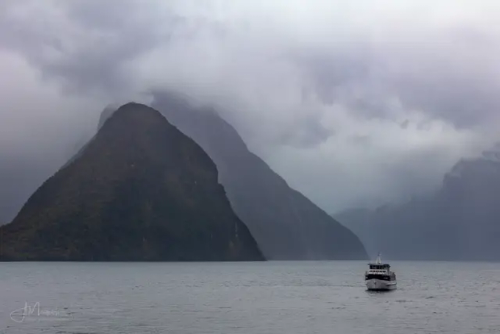
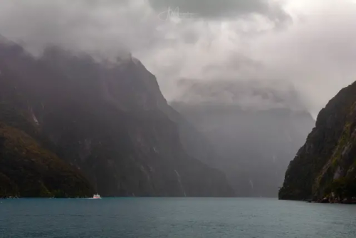


Милфорд Саунд (Milford Sound, маорийское название — Пиопиотахи (Piopiotahi)) – самый знаменитый фьорд в Новой Зеландии, известный на весь мир своей первозданной красотой. Милфорд Саунд, как и фьорды Северного полушария, сформировался в результате деятельности ледника 10-12 тысяч лет назад. Знаменитый английский путешественник и писатель Редьярд Киплинг побывал однажды на берегах Милфорд Саунд и под впечатлением увиденного назвал этот фьорд восьмым чудом света.
Милфорд Саунд – это вытянутый залив с высокими скалистыми берегами шириной около 3 км, который вдается в сушу на целых 16 км, а максимальная его глубина 512 м. Со всех сторон он окружен горными вершинами, увенчанные вечными снегами, высотой более 1,5 км. Нетронутые человеком густые влажные леса растут здесь практически на отвесных скалах.
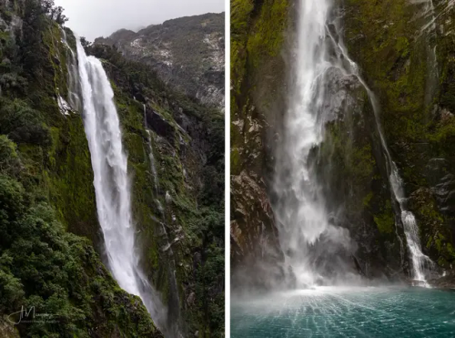
Милфорд Саунд - одно из самых влажных мест на Земле, здесь за год выпадает до 7000 мм осадков. Дождь идет каждый день и это сказывается на характере леса - гигантские деревья покрыты мхом и лианами, здесь растут лишайники и папоротники, лес очень влажный. Туристы могут рассчитывать на солнце в течение нескольких часов ближе к полудню, но во второй половине дня их наверняка настигнет ливень.
Интересный факт — В дождливые и бурные дни можно увидеть потрясающий природный феномен. Водопады, которые падают вверх. Это явление вызвано географическими особенностями Милфорд Саунда. При встрече с утесом сильный ветер часто поднимается вверх, и обычные водопады, попадая в поток воздуха, кардинально меняют свое направление.
Воды Милфорд Саунд населяет множество тюленей, пингвинов и дельфинов. Исследовательская станция Милфорд Дип позволяет ученым и туристам «заглянуть» в подводный мир. При таком изобилии мелких птиц невозможно обойтись без хищников: в глубине фьорда рассекают толщу воды многочисленные акулы. Также здесь можно увидеть уникальные коралловые рифы, в том числе и самые редкие виды - черные кораллы. Вода в Милфорд Саунд настолько прозрачная, что дно видно даже в самых глубоких местах, если, конечно, его не заслоняют густые водоросли.
Milford Sound (Maori name - Piopiotahi) is the most famous fjord in New Zealand, known throughout the world for its pristine beauty. Milford Sound, like the fjords of the Northern Hemisphere, was formed as a result of glacier activity 10-12 thousand years ago. The famous English traveler and writer Rudyard Kipling once visited the shores of Milford Sound and, impressed by what he saw, called this fjord the eighth wonder of the world.
Milford Sound is an elongated bay with high rocky shores about 3 km wide, which juts into the land for as much as 16 km, and its maximum depth is 512 m. On all sides it is surrounded by mountain peaks, crowned with eternal snow, more than 1.5 km high. Dense rainforests untouched by man grow here almost on sheer cliffs.
Milford Sound is one of the wettest places on Earth, with up to 7,000 mm of rainfall per year. It rains every day and this affects the character of the forest - giant trees are covered with moss and vines, lichens and ferns grow here, the forest is very humid. Tourists can expect sun for a few hours closer to midday, but in the afternoon they will probably be overtaken by a downpour.
Interesting fact - On rainy and stormy days, you can see an amazing natural phenomenon. Waterfalls that fall upwards. This phenomenon is caused by the geographical features of Milford Sound. When meeting a cliff, a strong wind often rises upwards, and ordinary waterfalls, getting into the air flow, radically change their direction.
The waters of Milford Sound are inhabited by many seals, penguins and dolphins. The Milford Deep research station allows scientists and tourists to "look" into the underwater world. With such an abundance of small birds, it is impossible to do without predators: in the depths of the fjord, numerous sharks cut through the water. Here you can also see unique coral reefs, including the rarest species - black corals. The water in Milford Sound is so transparent that the bottom is visible even in the deepest places, unless, of course, it is obscured by thick algae.
Источник: //mirsg.ru/ru/pages/milford-sound,//cattur.ru/australia-and-oceania/new-zealand/milford-saund.html,/australiantravelclub.ru /articles/milford_saund_i_paryashchie_vodopady.htm,/sunsetobsession.com/ru/milford-sound/,/mirsg.ru/ru/pages/milford-sound, /varlamov.ru/1250158.html,//wikiway.com/novaya-zelandiya/milford-saund/,vk.com/@greenfieldworld-novaya-zelandiya-fordlend-milford-saund.