1575 posts
The Ancient Namib Desert Is Home To Some Of The Tallest And Most Spectacular Dunes Of The World, Ranging
The ancient Namib Desert is home to some of the tallest and most spectacular dunes of the world, ranging in color from pink to vivid orange. These dunes continue right to the edge of the Atlantic Ocean. The cold ocean waters brush against the dunes of the Namib desert is one of the most surreal sights. While the sea coast extends for hundreds of miles, one of the best places to see these dunes is at Swakopmund. Known as Swakop in Namibia, it is the country's biggest coastal town and a mecca for Namibians on holiday. The city's German origins are quite pronounced in beautiful old German colonial buildings throughout the city, making an even starker contrast for this town sitting at the edge of the Namib Desert.
--------------
Die Namib-Wüste beherbergt einige der höchsten und spektakulärsten Dünen der Welt, deren Farbe von Pink bis zu leuchtendem Orange reicht. Diese Dünen setzen sich bis zum Rand des Atlantischen Ozeans fort. Das kalte Meerwasser, das gegen die Dünen der Namib-Wüste streift, ist einer der surrealsten Anblicke. Während sich die Meeresküste über Hunderte von Kilometern erstreckt, ist Swakopmund einer der besten Orte, um diese Dünen zu sehen. In Namibia als Swakop bekannt, ist es die größte Küstenstadt des Landes und ein Mekka für Namibier im Urlaub. Die deutschen Ursprünge der Stadt sind in den schönen alten deutschen Kolonialgebäuden in der ganzen Stadt ziemlich ausgeprägt, was einen noch stärkeren Kontrast zu dieser Stadt am Rande der Namib-Wüste bildet.


-
 bcacstuff liked this · 3 years ago
 -
 logi1974 liked this · 3 years ago
 -
 margus1-blog liked this · 3 years ago
More Posts from Logi1974
Sesriem is also known for Sesriem Canyon, about 4 km from Sesriem itself, which is the second most important tourist attraction in the area after Sossusvlei. It is a natural canyon carved by the Tsauchab river in the local sedimentary rock, about one kilometre long and up to 30 metres deep. The name Sesriem is Afrikaans and means "six thongs", given by settlers on the Dorsland Trek who had to join six rawhide thongs in order for a bucket to reach the water. Sesriem Canyon is only two metres wide in some places, and has a portion that permanently contains water, which many animals use.
-----------------
Sesriem ist unter anderem auch bekannt für den Sesriem Canyon, etwa 4 km von Sesriem selbst entfernt, der nach dem Sossusvlei die zweitwichtigste Touristenattraktion in der Gegend ist. Es ist eine natürliche Schlucht, die der Tsauchab-Fluss in das örtliche Sedimentgestein gegraben hat, etwa einen Kilometer lang und bis zu 30 Meter tief. Der Name Sesriem ist Afrikaans und bedeutet "sechs Riemen", gegeben von Siedlern auf dem Dorsland Trek, die sechs Rohleder Riemen verbinden mussten, damit ein Eimer das Wasser erreichen konnte. Der Sesriem Canyon ist an einigen Stellen nur zwei Meter breit und hat einen Bereich, der ständig Wasser enthält, das viele Tiere nutzen.


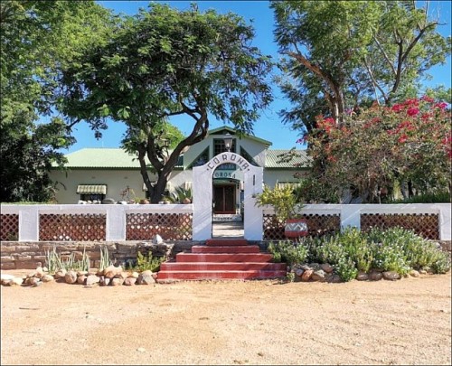
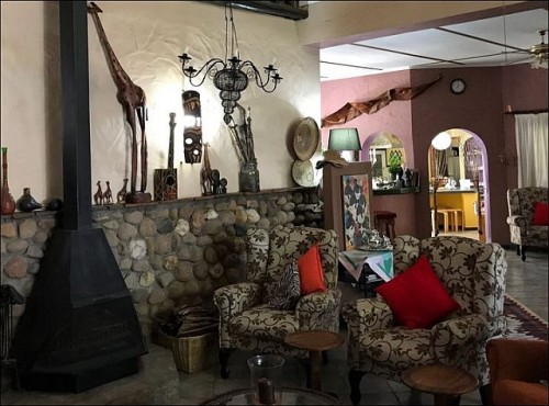
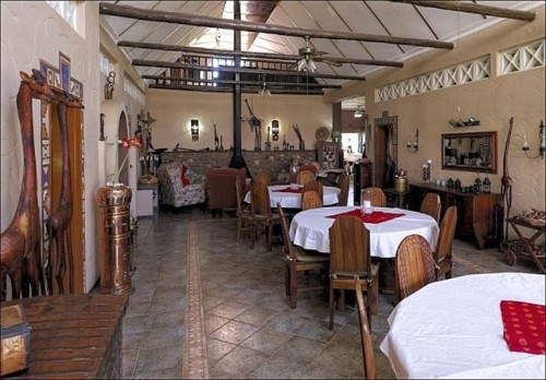
Corona Guest Farm greets guests with an awesome vista. Vast desert plains and unusually beautiful, barren, stone-clad veldt; mountains shimmering in the noon-day sun, their diverse colours glinting. Then there’s the Rantberg range, the extraordinarily light Witberg range and of course, the colossal table-top Gamsberg itself, showing off its mighty 2,347 metres to impressive effect. A mesmerising scene, surely as brilliant and harsh as the Namib at its best.
We have been able to trace the history of Corona as far back as the turn of last century. Two old wells, found in a riverbed, as well as old ox-wagon trails passing Rooi Huis, support the theory that one of the transport routes leading from the coast of the Namibian Hinterland went past Corona and Picadilly before “winding” up the Gamsberg Pass. The garden creates a safe haven for many various bird species, making it a “bird spotter” paradise. With all the breath-taking landscapes surrounding us, Corona is a photographer’s dream destination!
-------------
Die Corona Guest Farm begrüßt die Gäste mit einer fantastischen Aussicht. Weite Wüstenebenen und ungewöhnlich schöne, karge, mit Steinen bedeckte Steppe; Berge, die in der Mittagssonne schimmern und deren verschiedene Farben glitzern. Dann gibt es die Rantberg Stufe, die außergewöhnlich leichte Witberg Stufe und natürlich der kolossale Tafelberg Gamsberg selbst, der seine mächtigen 2.347 Meter eindrucksvoll zur Geltung bringt. Eine faszinierende Szene, sicherlich so brillant und hart wie die Namib von ihrer besten Seite.
Man kann die Geschichte der Gästefarm bis zur Jahrhundertwende zurückverfolgen. Zwei alte Brunnen in einem Flussbett sowie alte Ochsenkarrenwege, die an Rooi Huis vorbeiführen, stützen die Theorie, dass einer der Transportwege, die von der Küste des namibischen Hinterlandes führten, an Corona und Picadilly vorbeiführte, bevor er den Gamsberg erklomm. Der Garten ist ein sicherer Hafen für viele verschiedene Vogelarten und somit ein Paradies für Vogelbeobachter. Mit all den atemberaubenden Landschaften, die uns umgeben, ist Corona das Traumziel eines Fotografen!


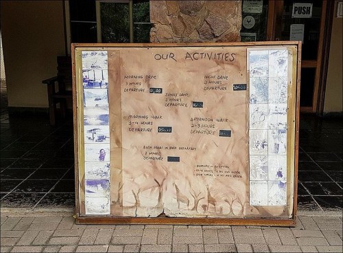
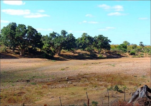
Shingwedzi lies in the northern part of the Kruger National Park in the heart of mopane country. A scenic game drive along the Shingwedzi River in a south-easterly direction towards the Kanniedood Dam is one of the most rewarding drives in the Park. Waterbuck, nyala, kudu and elephant are often seen here and the bird life is prolific. Staying overnight at Shingwedzi is an experience that will last a lifetime. It is a rustic camp that still carries the essence of the bush and is untouched by modern technology.
------------------------
Shingwedzi liegt im nördlichen Teil des Krüger-Nationalparks im Herzen des Mopane-Busches. Eine landschaftlich reizvolle Pirschfahrt entlang des Shingwedzi-Flusses in südöstlicher Richtung zum Kanniedood-Staudamm ist eine der lohnendsten Fahrten im Park. Wasserböcke, Nyala, Kudus und Elefanten werden hier oft gesehen und die Vogelwelt ist reich. Eine Übernachtung in Shingwedzi ist ein Erlebnis, das ein Leben lang anhält. Es handelt sich um ein rustikales Camp, das noch immer die Essenz des Busches hat und von moderner Technologie fast unberührt ist.


Usakos (Damara: grab the heel, Otjiherero name: Okanduu) is a city on the banks of river Khan, 140 kilometres north-east of Swakopmund in the Erongo Region of Namibia. It is located on the B2 (Trans-Kalahari Highway), the main road between the Walvis Bay and Johannesburg. The town has 3,000 inhabitants and owns 58 square kilometres of land. The settlement was founded in 1900 as a watering station for locomotives when railway construction workers from Otavi Minen- und Eisenbahngesellschaft (Otavi Mining and Railway Company) (OMEG) arrived here on their way from Swakopmund to Tsumeb.
---------------------------
Usakos (Damara: an die Ferse fassen, Otjiherero-Name: Okanduu) ist eine Stadt am Ufer des Flusses Khan, 140 Kilometer nordöstlich von Swakopmund in der Erongo-Region in Namibia. Der Ort liegt an der B2 (Trans-Kalahari Highway), der Hauptstraße zwischen Walvis Bay und Johannesburg. Die Stadt hat 3.000 Einwohner und besitzt 58 Quadratkilometer Land. Die Siedlung wurde 1900 als Wasserstation für Dampfloks gegründet, als Eisenbahnbauarbeiter der Otavi Minen- und Eisenbahngesellschaft (OMEG) auf ihrem Weg von Swakopmund nach Tsumeb hier ankamen.


Located on the outskirts of Khumaga village, Boteti River Camp is easily accessible whether driving from Maun, Nata, Kasane, or Khama Rhino Sanctuary making it a not-to-be-missed and easy addition to any Botswana safaris offering fantastic contrasts with the Okavango Delta, Moremi Game Reserve, Chobe National Park and the Central Kalahari Game Reserve. At Boteti River Camp, you will get to explore one of the world’s largest salt pans and observe Botswana’s unique rural culture in a friendly, comfortable and serene setting.
--------------------------------
Das Boteti River Camp liegt am Rande des Dorfes Khumaga und ist leicht erreichbar, egal ob man von Maun, Nata, Kasane oder Khama Rhino Sanctuary aus fährt. Das Camp ist eine schöne Ergänzung jeder Botswana-Safari, das fantastische Kontraste bietet gegenüber Okavango Delta, Moremi Game Reserve, Chobe National Park und dem Central Kalahari Game Reserve. Vom Boteti River Camp können Gäste eine der größten Salzpfannen der Welt erkunden und Botswanas einzigartige ländliche Kultur in einer freundlichen, komfortablen und ruhigen Umgebung kennen lernen.


